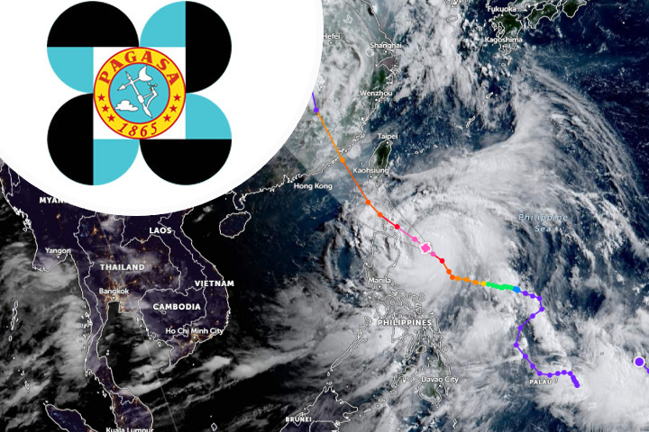
MANILA, Philippines — Cyclone Egay strengthened and became a severe tropical storm yesterday, according to the Philippine Atmospheric, Geophysical, and Astronomical Services Administration (PAGASA), which issued Tropical Cyclone Wind Signal No. 1.
According to PAGASA weather scientist Aldczar Aurelio, Egay (international name Doksuri) might intensify into a typhoon over the next 24 hours and reach a super typhoon by tomorrow.
“The rapid intensification of Severe Tropical Storm Egay is expected to happen within 72 hours,” Aurelio said.
According to the state weather agency, as of 5 p.m. of July 23, areas in Luzon covered by Tropical Cyclone Signal No. 1 are Catanduanes, eastern portion of Camarines Sur, including Garchitorena, Caramoan and Presentacion; northern portion of Aurora, including Casiguran and Dilasag; eastern portion of Isabela, including Dinapigue, Divilacan, Maconacon, Palanan, Ilagan City, San Mariano, Tumauini, San Pablo and Cabagan; and eastern portion of Cagayan, including Santa Ana, Gonzaga, Lal-lo, Gattaran, Baggao and Peñablanca.
The northern section of Eastern Samar, comprising San Policarpo, Oras, Arteche, and Jipapad, and the eastern portion of Northern Samar, including Lapinig, Gamay, Mapanas, Palapag, Laoang, Catubig, and Pambujan, are impacted by Signal No. 1.
The center of Egay was positioned 560 kilometers east of Daet, Camarines Norte, at 4 p.m. on July 23, with maximum sustained winds of 110 kilometers per hour in the core and gustiness of up to 135 kilometers per hour.
“We expect to raise tropical cyclone wind signals in areas in the Bicol region and Eastern Visayas. Based on our forecast, the highest wind signal can reach 3 or number 4 in extreme Northern Luzon but it can reach wind signal number 5 if the track of the typhoon changes to westward. We are monitoring this if it changes from the northwestward to westward direction,” Aurelio said.
Today, Catanduanes is projected to get 100 to 200 millimeters of rain, according to Aurelio.
Severe Tropical Storm Egay, he warned, may make landfall in extreme Northern Luzon by Wednesday morning and in Taiwan on Thursday morning.
“We expect Egay to weaken by Wednesday when it is near the Batanes area as because of the interaction to land and by Thursday and Friday, we expect the typhoon to weaken further as it is heading to Taiwan and China,” he added.
According to Aurelio, the southwest monsoon, or habagat, would bring precipitation to the northern section of Palawan, including the islands of Calamian, Polillo, and Cuyo, as well as Antique and Negros Occidentales.
Calabarzon, Mimaropa, Visayas, northern Zamboanga peninsula, Northern Mindanao, and Caraga will also see severe winds from the southwest monsoon.
“The rains will cause possible flooding and landslides especially in low-lying areas and near rivers,” Aurelio said.
He also stated that a gale warning will be issued in regions where waves can reach 4.5 meters.
Meanwhile, CAAP spokesman Eric Apolonio stated that area manager Cynthia Tumanut of the Bicol region stated that they are prepared and have taken innovative measures to protect airport facilities from damage caused by natural calamities such as typhoons, as the region is frequently visited by typhoons.
Tumanut and her colleagues developed a more convenient, trustworthy, ready-to-use, and durable storm shutter, which they invite other concerned airports to adopt. The CAAP oversees 81 airports and 12 regional centers around the country.